Sunday, January 22, 2012

Hawaii

A business trip to Honolulu last week (yes, when Olympia had a horrendous snow and ice storm...what can I say) afforded an opportunity to fly in the islands and log a few new airports.

Through some research I found an instructor at PHNL (Mike Richards...who is excellent) and agreed to meet him on Friday after my workday was finished.  We used his Cessna 172N (N5660E), which is the same species as N75898, though without the 180hp upgrade to the engine.  So I was already pretty familiar with the aircraft, though every plane's avionics are a bit different and it took a few minutes to get oriented.

PHNL is in Class B airspace (like KSEA), with a few extra rules and procedures.  The first difference is that VFR aircraft require an explicit clearance to enter the airspace, rather than just establishing two-way radio contact as at KOLM.  So after completing our preflight and orientation, Mike had me call up the delivery frequency for clearance.  I had studied the standard VFR departure procedures, and requested the Shoreline Four departure, which calls for a climb to 1500 and an immediate right turn after departing runway 4R/4L, then staying about a mile offshore past downtown Honolulu, Waikiki, and Diamond Head.  The clearance delivery controller granted the request, then had us switch to ground for taxi.

Though ground originally assigned us runway 4R, when we called the tower holding short, she reassigned us to 4L and had us "line up and wait" (first time I'd ever been issued that clearance!)  So we taxied onto 4L and watched a couple of big jets depart on runway 8L, which crosses 4L downfield.  Finally it was our turn to go, with caution for wake turbulence from the Alaska 737 that had just departed 8L, and for the helicopter that had just departed the ramp behind us.

Taxi route and takeoff from runway 4L. Runway 8L from top-left to right-center


We turned right offshore, and out the left-seat window I had a great view of Honolulu and Waikiki, then Diamond Head and Koko Head.  Just after we passed Diamond Head, the approach controller cleared us to climb on course...which was to Molokai (PHMK), 25 miles to the south over the Kaiwi Channel.  The crossing at 3500' went much more quickly than I thought it would, despite my checking every 30 seconds to make sure the oil pressure and temperature were right in the middle of the green, and RPM was right where I left it.  Mike had reviewed the overwater emergency kit with me during preflight, but I really hoped not to have to use it!

The view as we approached the north coast of Molokai was spectacular.  It's a very rural place, with stunning cliffs and beaches and not a lot of human development.  It's also a small island, so 5 minutes after crossing the shoreline, I contacted the tower (PHMK is a Class D field), setting up for a right downwind entry to runway 23 as instructed.  I was a little high on final--my excuse was beautiful scenery and an unfamiliar airplane--but the runway is long and I salvaged a decent landing.  A left crosswind departure followed, and a few minutes later we were over the south shore for another crossing--to Lanai.

The airport on Lanai (PHNY) is on the southwestern part of the island, just over the top of the rapid upslope from the north shore.  It is fairly high, at 1300', and right in the midst of a turbulent rotor layer from the northeastern trade winds flowing over the peak of the old volcanic cone.  There was quite a lot of rough air the whole way across the island, including in the pattern, but it smoothed out on final as I accomplished a nice touch-and-go landing on runway 3.

After the visit to Lanai, we climbed back to the northwest, headed back to Honolulu.  We had to dodge around several cloud layers west of Lanai, but after that we were treated to smooth air and a beautiful central Pacific sunset.  We requested radar vectors for runway 4R, which allowed for some good IFR practice.

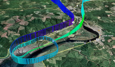
Entire flight route

To say this was an amazing experience, with spectacular scenery and very fun flying, would be an understatement.  I accomplished several firsts:  takeoff and landing at a Class B airport, flying over water outside gliding distance from shore, three new airports, two new Hawaiian islands visited...  A very rewarding couple of hours in the air.

Google Earth track is here.
Sunday, January 8, 2012

Recent landing videos (KOLM, KKLS)

Today I finally got around to posting a couple of videos from last month's cross country to Willapa Harbor and Kelso.

I discovered that I failed to turn the video camera on until after the landing at Willapa (should I add video camera steps to my checklists?)...so the first video is the landing at Kelso, and the second is a short approach and long landing back at Olympia.

The Olympia landing video really gives a good sense of the inversion at about 1000' that week, when we had very high pressure in western Washington for several days.

Happy new year everyone!

Saturday, December 10, 2011

2S9 and 100

A record spell of high pressure continues in the Pacific Northwest, giving us mostly low, cloudy days with poor air quality.  But a little low pressure system passed to the northeast of us yesterday, which gave just enough mix to the lower atmosphere to allow the scud to burn off.

By 1:00, we had just a few clouds at 1000 feet, and it was clearly improving further.  My boss was kind enough to let me take a long lunch, and by 1:30 I was at the hangar watching the last few wisps of cloud evaporate.  It was going to be a great day to fly!

It felt like the right day to tackle an airport I've been wanting to visit for the longest time:  Willapa Harbor (2S9).  I have actually visited this airport by car...when Michael and I went camping near the coast two summers ago, we drove by it on our way home and stopped in to check it out.  It's your typical sleepy little out-of-the-way airfield, that is nonetheless a critical component of the transportation infrastructure for the Raymond-South Bend area.  It offers terrific views of the bay best known for producing some of the best oysters in the world, and some interesting terrain nearby.

I flew pretty much direct from Olympia.  There was a strong inversion at 2000 feet, below which visibility was maybe 10 miles in haze, but above which it was unlimited.  A large wildfire was burning about 30 miles south of Raymond up in the Willapa Hills, and with light southerly winds, a plume of smoke was directly across my flight path.  I held my final descent into Willapa Harbor until clear of the smoke, and planned an overhead entry into the pattern so I could get a good look at the windsock (since 2S9 does not have automated weather).  The wind was maybe 8 knots, straight down runway 11, so I turned overhead for a left downwind, keeping it tight to avoid the terrain to the north of the airport.  I actually overshot final just a bit, but not so much that I couldn't correct.


After a landing I was happy with, I departed straight out and turned direct for Kelso (KKLS), which is far enough away from Olympia to allow me to log cross-country time.  (2S9 is only 46 miles from KOLM...4 short of the distance required to count as xc).  Kelso was busy...a helicopter departed just as I began monitoring the frequency, 15 miles out...another Cessna was in the pattern...and a Citation jet was holding short as I landed.  Good to see folks out enjoying the nice weather.  The Cessna in the pattern was just turning downwind to leave as I was a couple miles out on the 45, so I decided to circle to the west to give him time to depart.  I probably could have worked in behind him, but I figured to play it safe.

On the way back to Olympia, I flew over a solid stratus deck that extended from 10 north of Kelso to 10 south of Centralia.  It was beautiful...serene...but also a little problematic if the fan quit turning, so I climbed to 6500 to give me more options.  The Cascade peaks to the east--Rainier, St. Helens, Adams--were stunning on the horizon.

Back at the home patch, I practiced a no-flap landing, did a touch-and-go, and back around for a simulated engine-out landing.


Google Earth track is here.

One final note:  12 minutes out of Olympia, headed for Willapa, I crossed the 100 hour milestone.  It was a perfect flight to do it!

Monday, November 28, 2011

Olympia in November

At one point, around lunchtime today, I thought I might actually go flying this evening.

As I drove the two miles to the airport, I saw ground fog forming before my eyes.  At that point, I knew I wouldn't be flying, but since I had the camera with me, I continued on, hoping for some cool dusky-foggy photo opportunities.

Sure enough, when I arrived at the hangar, I saw this:


It was a very good lesson in how fast the murky gloom can descend upon us here in the south sound...and how the forecasts can be oh-so-wrong with just a two degree difference in temperature.

Even now, two hours later, all the fields to the north are CAVU.  But probably not for long.

It is late November, after all.

Thursday, November 24, 2011

Thanksgiving

While making the apple pie this morning, I was thinking about the things I am thankful for as a pilot.  And now I will share these things with you:

  1. I'm thankful for a family that recognizes the joy I get from flying, and accepts all that goes with it
  2. I'm thankful for the opportunity to fly within the best general aviation environment of any nation on earth, and for the responsibility as a citizen aviator to make sure it stays that way
  3. I'm thankful for every mechanic that worked on 75898 this year and ensured it returned to service in an airworthy condition
  4. I'm thankful for an instructor who taught me stick-and-rudder skills and how to be safe in the air
  5. I'm thankful for the dedicated public servants who work in the tower at KOLM, the Seattle TRACON, and the Seattle ARTCC, for all you do to help keep us safe
  6. I'm thankful that there is a flying club at KOLM with great aircraft and a commitment to safety, allowing me to fly at the lowest cost possible
  7. I'm thankful that this year, a group of entrepreneurs took a risk and started PilotEdge, which provides a key component of a realistic simulation environment that allows me to practice when the weather outside is frightful
  8. I'm thankful for iPad and ForeFlight
  9. I'm thankful for the Pacific Northwest Flying forum and the community of pilots in the PNW who share a love of flying
  10. I'm thankful, every time I lift into the air, for the opportunities I have to see Mount Rainier out the window, watch the sun set over Gray's Harbor, fly over KSEA at 1500 feet and hear my buddy say "that was awesome", and deliver a skiddish Irish Setter to his new adoptive family.


Thanks for reading, and I wish you a blessed and happy Thanksgiving!
--Scott

Wednesday, November 2, 2011

Instrument Practice

I've really been thinking about jumping back into instrument training.  There was a discussion on the Pacific Northwest Flying forum this week, started by my friend Ted...just the latest in several recent happenings that have me thinking seriously about it.

So...I reserved 75898 for Tuesday evening, called up my instrument-rated friend Cameron and asked if he could be safety pilot for a simulated instrument cross-country to Kelso (KKLS).  He was up for it, so we launched at 5.  I shot the RNAV GPS approach to runway 12 at Kelso, then shot the ILS 17 at Olympia.  The GPS approach was nothing to write home about...I clearly need more in-depth training on using the Garmin 430 for approaches.  But I was pretty pleased with the ILS.  It was my first time flying a procedure turn, and I don't think it turned out too bad:

Flight Track of the ILS 17, full approach from the VOR
Flight track is here.

Saturday, October 15, 2011

Red Baron

With a title like that, you might think this post is about Manfred von Richthofen, World War I flying, or Snoopy and the flying doghouse.

But it's not.  Red Baron was my latest passenger, on a flight from Olympia to Hillsboro, Oregon (KHIO) on Thursday evening.  He is a 45-pound Irish Setter, and my job was to transport him on the last leg of his journey from Utah to his adoptive family.  The flight was my first rescue flight through Pilots-N-Paws, and it was a great experience.

The adventure began a week earlier, when a Alissa from the Setter rescue organization posted to the PnP forum that Red needed transport from Tacoma to the Portland area.  At the time, it looked like Thursday would offer a break in the low fall weather, so I volunteered.  Logistics started coming together as the week went on...I contacted Larry, who fostered Red in Tacoma, and Mary, his adoptive mom in Coos Bay, Oregon.  I called the great folks at Aero Air, an FBO at KHIO, and arranged for ramp parking and a place to meet Mary on Thursday evening.

Our biggest challenge was a crate for Red to occupy during the flight, since a dog (timid or not) will never  ride loose in my cockpit.  The crate that Larry had was too big to fit in 75898, so Alissa and I made several phone calls trying to find an alternative in Olympia.  After all of those fell through, I knocked on a few doors in our neighborhood, and discovered that the Sharps, down the street, had a perfect sized carrier.

With that last problem solved, and my last conference call of the day wrapped up just before 5, I headed out to the airport.  I had just enough time to complete the preflight before Larry showed up with Red.  He went right into the crate in the backseat, said his goodbyes to Larry, and off we went.

Red and Larry at KOLM
I made extra sure to climb and descend gradually, to try to minimize any pressure problems in Red's ears.  Fortunately it was a very smooth flight, with calm winds at 5500, but it was chilly enough (about 30 degrees) that I used cabin heat for the first time since the spring.  I maintained a course of 165 all the way to KHIO, and arrived 5 minutes later than the time I had given to Aero and Mary...7:05.  Not bad. A 40-minute flight, compared to a 2.5 hour drive...much better for Red, and a lot more fun for me!

Mary showed up around 7:15--her timing couldn't have been better--and we accomplished the transfer quickly, as I was watching the temp and dewpoint converge, which meant fog was on the way.  Red was all wags and took to Mary right away, though I'm not sure he understood he had a much longer trip to Coos Bay in store for the rest of the evening...almost 4 hours in Mary's truck.

The flight back was uneventful...more smooth air, but completely dark.  I followed I-5 a little more closely on the way home...just a little extra security, since that route means I'm never further than about 20 miles from an airport.  It was quite turbulent in the pattern at Olympia, but I decided to work in an extra landing, to update my night currency.

I discovered that it's possible to extract timestamps from my GPS track using gpsvisualizer.com, which causes Google Earth to display a time slider control.  Cool!  The Google Earth layer is here.

Here are a couple of images from Google Earth that I captured...

A view of the approach into KHIO...right downwind entry for runway 31:


And a view of the entire flight from 28 miles above Yakima, with Mt. Adams and Mt. St. Helens in the foreground, and Pacific in the background:


This was a great experience, and Pilots-N-Paws is a terrific organization.  It really takes a lot of coordination to pull off a rescue flight...more than I expected.  And, as fun as it was for me, my role was really pretty minimal compared to the others...Larry drove Red to Tacoma from Utah earlier in the week, and cared for him for several days while we arranged the flight.  And Mary has opened her home to this needy pup who will likely require patience and care as he transitions from his time in the pound and in transit.  Alissa and the many rescue coordinators like her put in a great deal of time, effort, and resources to find homes for these animals.  It's an honor to be a small part of a good cause, and now that I've completed one mission I can hardly wait for the next one!